


My journey into map development began with the goal of implementing Mapbox into my Android project. Along the way, I discovered a game-changer: the Quadtree data structure. Although I hadn't directly applied Quadtree to my map development project, the insights I gained from Mapbox's use of this powerful data structure were enlightening. Mapbox's utilization of Quadtree to provide smooth zooming capabilities intrigued me, and I realized that understanding this concept could significantly impact my approach to map development.
The Power of Quadtree
In this article, I'd like to share my journey of discovering Quadtree and how this ingenious data structure, even indirectly, can enhance map zooming and improve the overall user experience. Let's explore the magic of Quadtree and its relevance in the world of map development.
Maps have become an integral part of our daily lives, aiding us in navigation, location-based services, and various applications across different domains. One crucial aspect of map interfaces is the ability to zoom in and out smoothly, allowing users to explore locations at different levels of detail. Behind this seemingly simple functionality lies the complexity of managing large amounts of spatial data efficiently. This is where the Quadtree data structure comes into play.
Understanding Quadtree
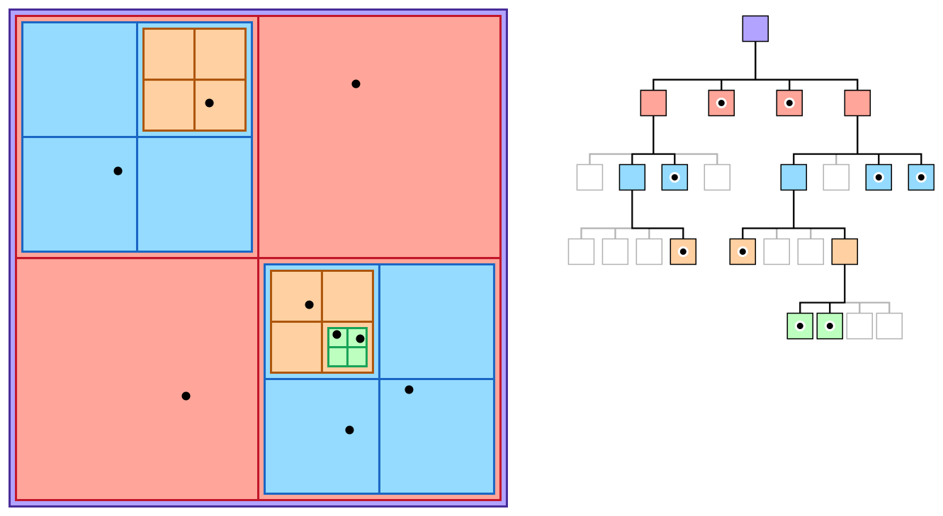
A Quadtree is a hierarchical data structure used for the efficient storage and retrieval of spatial data. It divides a two-dimensional space into four quadrants, each representing a smaller portion of the overall area. These quadrants can further be subdivided into four more quadrants, and so on, creating a tree-like structure. This recursive subdivision allows Quadtree to efficiently manage spatial data, making it a perfect choice for implementing zooming features in maps.
Zooming Out: Aggregation of Data
When a user zooms out on a map, the Quadtree can aggregate data points at higher levels of the tree. Initially, each leaf node of the Quadtree may represent a single data point or a small cluster of points. As we zoom out, these leaf nodes are combined into parent nodes, which represent larger regions. This process continues as the user zooms out further, reducing the amount of data that needs to be rendered and improving performance.
Subdividing the Map
At the highest zoom level, each quadrant may represent a continent or a large country.
As the user zooms out, these quadrants merge to represent larger regions like continents.
This hierarchical aggregation reduces the number of data points to render, improving efficiency.
Resource Optimization
Aggregating data reduces the need to fetch and process individual data points.
It conserves memory and computational resources, making maps accessible on a wider range of devices.
Zooming In: Detailed Data Retrieval
Conversely, when a user zooms in, Quadtree facilitates the retrieval of detailed data efficiently. It identifies the region of interest and traverses the tree to retrieve only the relevant leaf nodes or clusters of data points within that region. This minimizes the amount of unnecessary data retrieval, ensuring a smooth and responsive user experience.
Focusing on Specific Areas
Quadtree dynamically loads data for the region the user is zooming into.
Detailed data, such as street-level information, becomes available as needed.
This dynamic loading prevents excessive data transfer and speeds up rendering.
Enhancing User Interaction
Quick and precise data retrieval ensures a seamless user experience.
Users can explore maps at various levels of detail without experiencing lag or delays.
Dynamic Adjustments
Quadtree is not static; it dynamically adapts to changes in the map view. When new data points are added or existing ones are updated, the Quadtree can be updated accordingly, ensuring that the zooming feature continues to function optimally even as the underlying data evolves.
Real-Time Updates
Quadtree can handle real-time updates, making it suitable for applications with dynamic data.
Examples include traffic updates, user-generated content, and live location tracking.
Scalability
As maps grow in size and complexity, Quadtree can accommodate the expansion of data.
It can handle large datasets, making it suitable for global-scale mapping applications.
Benefits of Using Quadtree for Zooming in Maps
Optimized Performance: Quadtree's ability to aggregate and retrieve data efficiently reduces the computational load and speeds up the rendering of maps during zoom operations.
Conservation of Resources: By loading only the necessary data, Quadtree helps conserve network bandwidth and system resources, making maps more accessible on a variety of devices and network conditions.
Seamless User Experience: The seamless zooming experience enhances user satisfaction, making maps more user-friendly and engaging.
Dynamic Data Handling: Quadtree can handle dynamic datasets, making it suitable for applications that involve real-time updates and user-generated content.
Conclusion
The implementation of a zooming feature in maps is essential for providing users with a smooth and interactive experience. Quadtree data structures offer an elegant solution to manage spatial data efficiently, making it possible to zoom in and out seamlessly while conserving resources and ensuring optimal performance.
As technology continues to advance, the demand for more sophisticated map applications will grow. By understanding and leveraging data structures like Quadtree, developers can build maps that not only meet but exceed user expectations, creating a more immersive and enjoyable navigation experience. Quadtree's versatility and adaptability make it a valuable tool in the world of modern cartography and location-based services.